



BMKG Intensifies Monitoring of Anak Krakatau Eruption
- 07 Sep 2026 12:45 WIB
- Voice of Indonesia
Key Points
- The Meteorology, Climatology, and Geophysical Agency (BMKG) has intensified 24-hour monitoring of the Anak Krakatau volcano eruption and its potential impacts on aviation and sea conditions around the Sunda Strait.
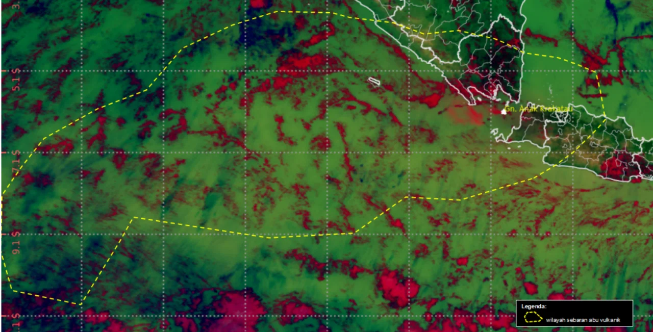
RRI.CO.ID, Jakarta - The Meteorology, Climatology, and Geophysical Agency (BMKG) has intensified 24-hour monitoring of the Anak Krakatau volcano eruption and its potential impacts on aviation and sea conditions around the Sunda Strait. Based on satellite imagery analysis conducted on Sunday, September 6, 2026, at 8 a.m. local time, BMKG identified two clusters of volcanic ash spreading across Banten, Jakarta, West Java, and Bengkulu.
BMKG Acting Deputy for Meteorology Andri Ramdhani said the Soekarno-Hatta Meteorological Station in Tangerang had issued Significant Meteorological Information (SIGMET) for aviation since the initial eruption on September 4, 2026. As of Sunday, September 6, a total of 18 SIGMET advisories had been issued periodically to support flight safety and air navigation.
“The latest SIGMET update shows that the ash plume is moving at altitudes of up to 20,000 feet toward the east and up to 50,000 feet toward the west,” Andri said.
Andri explained that volcanic ash at altitudes of up to 20,000 feet was moving from the northeast toward the south, affecting parts of Jakarta, Banten, West Java, and surrounding waters. Meanwhile, ash at altitudes of up to 50,000 feet was moving from the southwest toward the northwest, covering Banten, Lampung, Bengkulu, the southern part of the Sunda Strait, and the Indian Ocean.
Meanwhile, BMKG Acting Deputy for Geophysics Ardhasena Sopaheluwakan said monitoring of sea conditions around the Sunda Strait had detected no sea-level anomalies. As of 7 a.m. local time, 20 tsunami gauges around the Sunda Strait had recorded no changes indicating tsunami activity, while analysis from the HF Radar Array in Carita and Tanjung Lesung showed a low probability of a tsunami.
“BMKG has recorded secondary phenomena in the form of geomagnetic disturbances and volcanic lightning. Sensors in South Lampung and Serang recorded geomagnetic disturbances that coincided with an increase in volcanic lightning over the past 12 hours. However, the intensity of these disturbances was not as high as during the initial eruption,” he stated.
The agency continues to optimize integrated 24-hour monitoring using multiple instruments in coordination with the Center for Volcanology and Geological Hazard Mitigation (PVMBG), the Geological Agency, and other relevant authorities. Residents, particularly those carrying out activities along the Sunda Strait coastline, are urged to remain calm and vigilant and to follow official information from BMKG, the Geological Agency/PVMBG, and other authorized government institutions.
News Recomendation
Loading latest news.....