
Mount Semeru Erupts with 1,000-Meter Ash Column, Remains on Alert Status
- 19 Jun 2026 08:39 WIB
- Voice of Indonesia
Key Points
- Mount Semeru erupted with a 1,000-meter-high ash column and recorded 12 eruptions throughout the day.
- Authorities maintain Alert (Level III) status and enforce exclusion zones due to risks of pyroclastic flows, lava avalanches, and lahars.
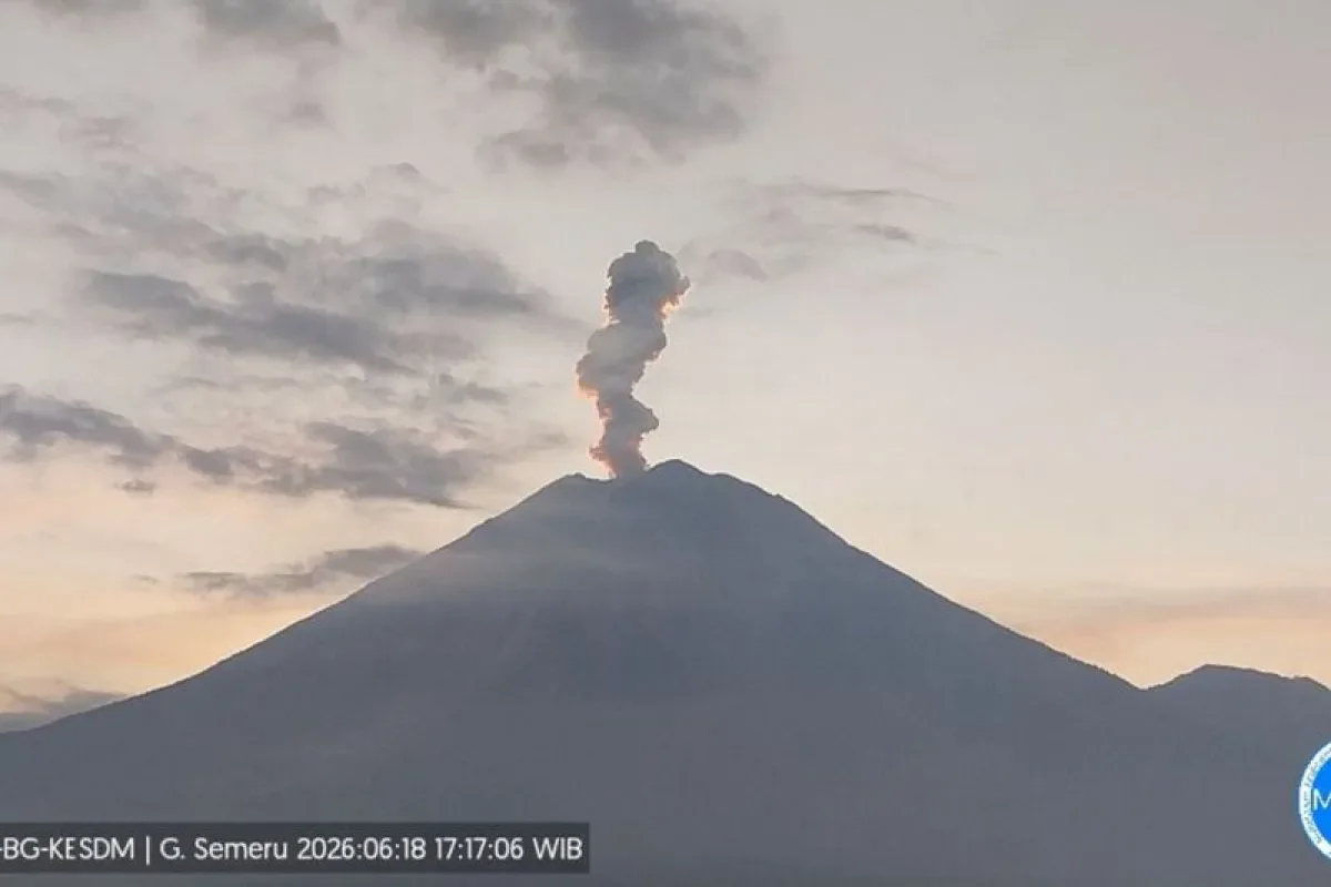
RRI.CO.ID, Lumajang - Mount Semeru, the highest volcano on Java Island straddling the border of Lumajang and Malang regencies in East Java, experienced a significant eruption on Thursday evening, June 18, 2026, sending a thick column of volcanic ash 1,000 meters into the sky.
The major blast, recorded at 5.15 p.m. local time, produced an ash plume that reached an absolute altitude of approximately 4,676 meters above sea level. Seismograph data tracked the visual event with a maximum amplitude of 22 mm and a total duration of 165 seconds.
The Center for Volcanology and Geological Mitigation (PVMBG) noted that the ash column appeared white to gray in color with a dense, thick intensity drifting directly toward the southwest.
Thursday's evening blast was part of a broader, highly active eruptive phase for the volcano. According to official observation logs, Mount Semeru erupted 12 times between 5.00 a.m. and 5.30 p.m. local time on Thursday alone, with individual ash plumes varying in height from 500 meters to 1,200 meters above the crater rim.
Mount Semeru Observation Post Officer Mukdas Sofian confirmed via a written report that the volcano's volcanic activity remains securely anchored at Status Level III (Alert).
In light of the persistent seismicity, volcanologists have re-emphasized zero-activity exclusion zones to safeguard local settlements and prevent casualties.
"Mount Semeru erupted at 17.15 local time with the height of the eruption column observed at around 1,000 meters above the peak or 4,676 meters above sea level (masl)," said Mount Semeru Observation Post Officer Mukdas Sofian in a written report received in Lumajang, as quoted by Antara.
Under the current Level III status, authorities have strictly banned all human activity within a 5-kilometer radius of the active crater due to the severe threat of incandescent rock projectiles. Furthermore, a strict 13-kilometer exclusion zone has been established along the southeastern sector following the path of the Besuk Kobokan riverbed, which serves as the primary channel for pyroclastic flows (awan panas).
Beyond the 13-kilometer perimeter, residents are instructed to stay at least 500 meters away from the banks of the Besuk Kobokan river structure. Volcanologists warn that expanding pyroclastic flows and secondary volcanic mudflows (lahar) could travel up to 17 kilometers down the mountain profile.
Officials urge local populations to remain highly vigilant against the triple threats of hot ash clouds, lava avalanches, and rain-triggered lahars along any valleys or river systems originating from Mount Semeru's summit.
Critical drainages under close monitoring include Besuk Kobokan, Besuk Bang, Besuk Kembar, and Besuk Sat, alongside smaller interconnected tributaries. Concurrently, the Bromo Tengger Semeru National Park Office (BB TNBTS) has intensified joint security patrols across access routes to intercept and prevent illegal hikers from entering the hazardous high-altitude zones. ***
News Recomendation
Loading latest news.....