
Mount Semeru Erupts Multiple Times on Saturday Morning
- 18 Apr 2026 11:33 WIB
- Voice of Indonesia
Key Points
- Mount Semeru erupted six times within six hours, with ash columns reaching up to 700 meters.
- PVMBG maintains Level III alert and enforces a 13-km exclusion zone in Besuk Kobokan due to ongoing risks.
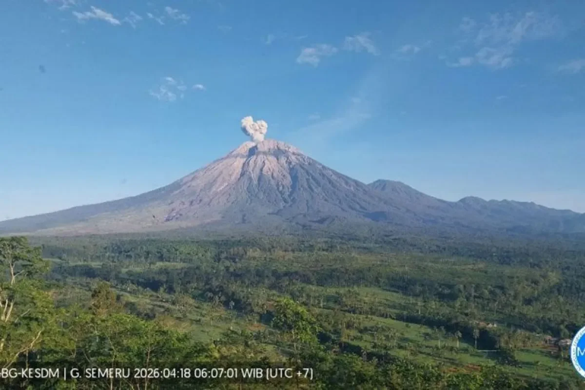
RRI.CO.ID, Lumajang - Mount Semeru, the highest peak on Java Island, recorded a series of eruptions early Saturday morning, April 18, 2026. The most significant blast occurred at 05:26 WIB, sending a volcanic ash column approximately 700 meters above the summit, or roughly 4,376 meters above sea level.
An officer at the Mount Semeru Observation Post, Liswanto, reported that the ash column appeared white to gray with moderate intensity, drifting toward the southwest. "The eruption was still ongoing at the time the report was filed," he noted in a written statement received in Lumajang, as quoted by Antara.
The volcano, situated on the border of Lumajang and Malang regencies, East Java, has shown heightened activity over a short window. According to official data, Mount Semeru erupted six times within a six-hour period between 00.00 WIB and 06.00 local time on Saturday.
The heights of these eruptions varied between 300 and 700 meters above the crater. Due to this consistent activity, Mount Semeru remains at Level III (Alert) status.
In response to the current volcanic state, the Volcanology and Geological Mitigation Center (PVMBG) has issued strict safety protocols to protect local residents and visitors. Authorities have established an exclusion zone, stating that no activities are permitted in the southeastern sector along Besuk Kobokan within a 13-kilometer radius from the summit.
Furthermore, regarding river proximity, residents are strongly advised to stay away from riverbanks that serve as paths for lava flows and cold lava (lahars) due to the high risk of secondary hazards.
The frequency of Semeru's eruptions, six times in just six hours, indicates a highly dynamic internal pressure system. While 700 meters is not a catastrophic height for this particular volcano, the southwest drift of the ash is a critical detail for local aviation and agriculture in the Malang region.
The 13-kilometer exclusion zone in the Besuk Kobokan area is a reminder of the 2021 disaster, the geography there acts as a natural funnel for pyroclastic flows. With the current Level III status, the situation is a delicate balance of constant monitoring.
For those living in the shadow of the volcano, these frequent smaller eruptions are a double-edged sword: they may act as a pressure release valve, but they also signal that the mountain’s magmatic plumbing is wide open and highly unpredictable. ***
News Recomendation
Loading latest news.....