
Mount Semeru Heightens Activity with Double Friday Morning Eruptions
- 27 Mar 2026 17:00 WIB
- Voice of Indonesia
Key Points
- Mount Semeru experienced two eruptions on Friday morning, March 27, 2026, with the height of the ash column reaching 1,000 meters (at 5.27 a.m. Jakarta time) and 700 meters (at 7.47 a.m. Jakarta time) respectively
- Mount Semeru remains under Level III or Watch alert, a status that carries heavy restrictions on human activity near the danger zones.
- Safety officials have emphasized that the summit itself is extremely hazardous, maintaining a five-kilometer "no-go" radius to protect the public from volcanic projectiles.
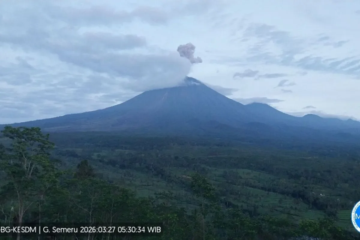
RRI.CO.ID, Lumajang - Authorities have issued fresh safety warnings for East Java’s highest peak after Mount Semeru unleashed two significant eruptions early Friday morning, March 27, 2026.
The volcanic activity on the border of Lumajang and Malang regencies sent thick ash clouds 1,000 meters above the summit. This prompted officials to reinforce strict exclusion zones for both local residents and visitors.
The first vertical blast was recorded at 5:27 a.m. Jakarta time, thrusting a dense grey ash column to an altitude of 4,676 meters above sea level. According to Yadi Yuliandi, an officer at the Mount Semeru Observation Post, the eruption was captured on a seismograph with a maximum amplitude of 22 mm and lasted for 168 seconds.
"The first eruption occurred at 5:27 a.m. Jakarta time with an observed eruption column height of approximately 1,000 meters above the peak," reported Yadi in a written statement received in Lumajang, as quoted by Antara.
The volcano remained restless, triggering a second eruption shortly after at 7:47 a.m. Jakarta time. This secondary burst produced a white-to-grey ash plume reaching 700 meters above the crater, drifting steadily toward the northeast.
While the second event was slightly shorter at 140 seconds, it maintained the same maximum seismic amplitude of 22 mm, signaling continued internal pressure within the mountain.
Mount Semeru remains under Level III or Watch alert, a status that carries heavy restrictions on human activity near the danger zones. The Center for Volcanology and Geological Hazard Mitigation (PVMBG) has prohibited all activities in the southeastern sector along Besuk Kobokan, extending 13 kilometers from the summit.
Furthermore, a 500-meter buffer zone has been established along the riverbanks of Besuk Kobokan due to the high risk of pyroclastic flows and lahar floods that could travel as far as 17 kilometers from the epicenter.
Safety officials have emphasized that the summit itself is extremely hazardous, maintaining a five-kilometer "no-go" radius to protect the public from volcanic projectiles. "People are also prohibited from carrying out activities within a five-kilometer radius of the crater/peak of Mount Semeru, as it is prone to the danger of incandescent rock ejecta," added Yadi.
Residents are urged to remain vigilant against the potential for lava flows and lahars along the river systems originating at the peak, specifically Besuk Kobokan, Besuk Bang, Besuk Kembar, and Besuk Sat, as well as smaller tributaries in the region. ***
Source: https://banten.antaranews.com/berita/377054/gunung-semeru-erupsi-dua-kali-tinggi-letusan-1000-meter
News Recomendation
Loading latest news.....