
Mount Semeru Unleashes Pyroclastic Flows Stretching 4.5 Kilometers
- 19 Jun 2026 15:54 WIB
- Voice of Indonesia
Poin Utama
- Mount Semeru erupted Friday morning, generating pyroclastic flows that traveled approximately 4.5 kilometers toward Besuk Kobokan.
- Authorities maintained Alert Level III status and warned residents to stay clear of designated danger zones due to ongoing eruption and lahar risks.
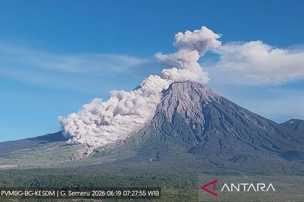
RRI.CO.ID, Lumajang - Mount Semeru, the highest volcano on Java Island positioned on the border of Lumajang and Malang Regencies, East Java, escalated its eruptive activity on Friday morning, unleashing dangerous pyroclastic flows that surged kilometers down its slopes.
The major morning blast, recorded at 7.21 a.m. local time, sent a dense column of volcanic ash rising 1,000 meters above the crater rim, reaching an absolute altitude of approximately 4,676 meters above sea level.
According to seismogram readings from the Mount Semeru Observation Post, the eruption registered a maximum amplitude of 22 mm and lasted for approximately 5 minutes and 33 seconds.
Mount Semeru Observation Post Officer Mukdas Sofian confirmed that the visual ash plume appeared white to gray with a thick intensity, drifting heavily toward the north and northwest. Crucially, the explosion triggered severe secondary hazards.
"The eruption of Mount Semeru was accompanied by pyroclastic flows with a sliding distance of approximately 4.5 kilometers toward Besuk Kobokan," he explained, as quoted by Antara.
Friday morning's pyroclastic event marks a persistent and highly volatile phase for the volcano. By mid-morning Friday, observation logs had already recorded six distinct eruptions during the day, with individual ash plumes ranging from 700 to 1,000 meters above the summit.
Due to this sustained volcanic unrest, Mount Semeru remains strictly anchored at Status Level III (Alert). Volcanologists have re-issued strict safety warnings, ordering local communities and regional agencies to enforce zero-activity exclusion zones along known volcanic channels.
"An eruption of Mount Semeru occurred on Friday at 7.21 a.m. local time with an observed eruption column height of around 1,000 meters above the peak or 4,676 meters above sea level," said Mount Semeru Observation Post Officer Mukdas Sofian in Lumajang.
Under the current Level III mandates, all human activity is strictly prohibited within a 5-kilometer radius of the active crater to prevent casualties from incandescent rock projectiles. Additionally, a strict 13-kilometer safety parameter remains active along the southeastern sector following the Besuk Kobokan riverbed.
Beyond that 13-kilometer zone, local residents are prohibited from coming within 500 meters of the riverbanks along Besuk Kobokan. Disaster management officials warn that expanding pyroclastic surges and secondary volcanic mudflows (lahar) could flow up to 17 kilometers from the summit if triggered by rain.
The public is urged to maintain high vigilance along all river valleys originating from the volcano's peak. Vulnerable channels include Besuk Kobokan, Besuk Bang, Besuk Kembar, and Besuk Sat, alongside smaller interconnected tributaries. Disaster mitigation agencies continue to monitor these sectors closely to manage potential evacuations as volcanic activity fluctuates. ***
News Recomendation
Memuat berita terbaru.....