



Govt Steps Up Forest Fire Response as National Hotspots Reach 1,532 Hotspots
- 21 Sep 2026 14:37 WIB
- Voice of Indonesia
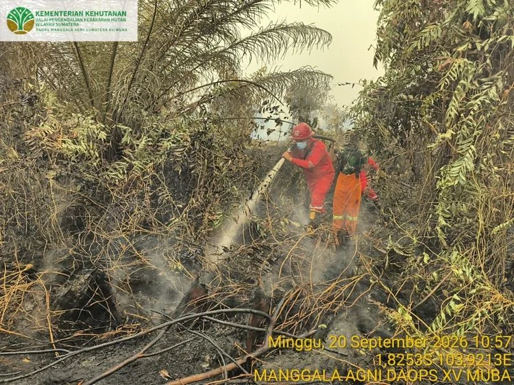
RRI.CO.ID, Jakarta - The Indonesian government is stepping up efforts to tackle forest and land fires in several parts of the country following an increase in satellite-detected hotspots. As of Sunday night, September 20, 2026, a total of 1,532 high-confidence hotspots had been detected across Indonesia.
According to data from the Ministry of Forestry’s SiPongi monitoring system, based on observations from the NASA Terra/Aqua, SNPP, and NOAA-20 satellites, the figure increased by 209 hotspots from 1,323 recorded the previous day.
Central Kalimantan remained the province with the highest number of high-confidence hotspots among the six priority provinces, with 968 hotspots. However, the figure declined from 1,035 hotspots recorded on Saturday, September 19, 2026. Meanwhile, South Sumatra saw the most significant increase, from 112 to 285 hotspots.
In addition to Central Kalimantan and South Sumatra, hotspots were detected in West Kalimantan with 98, South Kalimantan with 39, Jambi with 26, and Riau with one. The government is paying particular attention to the increase in hotspots in South Sumatra when determining operational priorities.
The government is strengthening its response through ground and aerial operations, including water bombing, aerial patrols, wetting and cooling efforts, as well as weather modification operations. Cabinet Secretary Teddy Indra Wijaya said the government has deployed 64 aircraft and helicopters and 54,394 joint personnel since August to tackle forest and land fires in affected areas.
The operations involve the Ministry of Forestry’s Manggala Agni firefighting teams, along with personnel from the Indonesian Military (TNI), National Police, National Disaster Management Agency (BNPB), Meteorology, Climatology and Geophysical Agency (BMKG), Regional Disaster Management Agencies (BPBD), local governments, communities, businesses, and volunteers. Field teams are carrying out patrols, direct firefighting, firebreak operations, mop-up activities, wetting, and cooling efforts.
The Ministry of Forestry emphasized that hotspots are indicators of surface temperature anomalies detected by satellites and cannot be directly equated with individual fire incidents or the total area burned. Each indication must still be verified through ground checks and actual conditions in the field.
In Central Kalimantan, haze remains a challenge for firefighting operations and community activities. On Sunday, September 20, visibility at Tjilik Riwut Airport in Palangka Raya temporarily dropped to around 600 meters, affecting 14 aircraft movements, including seven arrivals and seven departures.
Meanwhile, the BMKG warned of a potential increase in hotspots in South Sumatra due to relatively dry conditions. Several areas have experienced long to extremely long dry spells, with some locations recording more than 60 consecutive days without rain and reaching the extreme drought category.
The government is also strengthening efforts to maintain peatland moisture through water management and water-injection measures. People in affected areas are advised to monitor air quality information and follow guidance from local authorities, as well as reduce outdoor activities if air quality deteriorates.
News Recomendation
Loading latest news.....