
Mount Semeru Erupts Five Times, Plumes Reach Heights of 1,200 Meters
- 16 Apr 2026 09:25 WIB
- Voice of Indonesia
Key Points
- Mount Semeru erupted five times on April 16, 2026.
- Ash columns reached up to 1,200 meters above the summit.
- Mount Semeru remains at Level III (Alert) status.
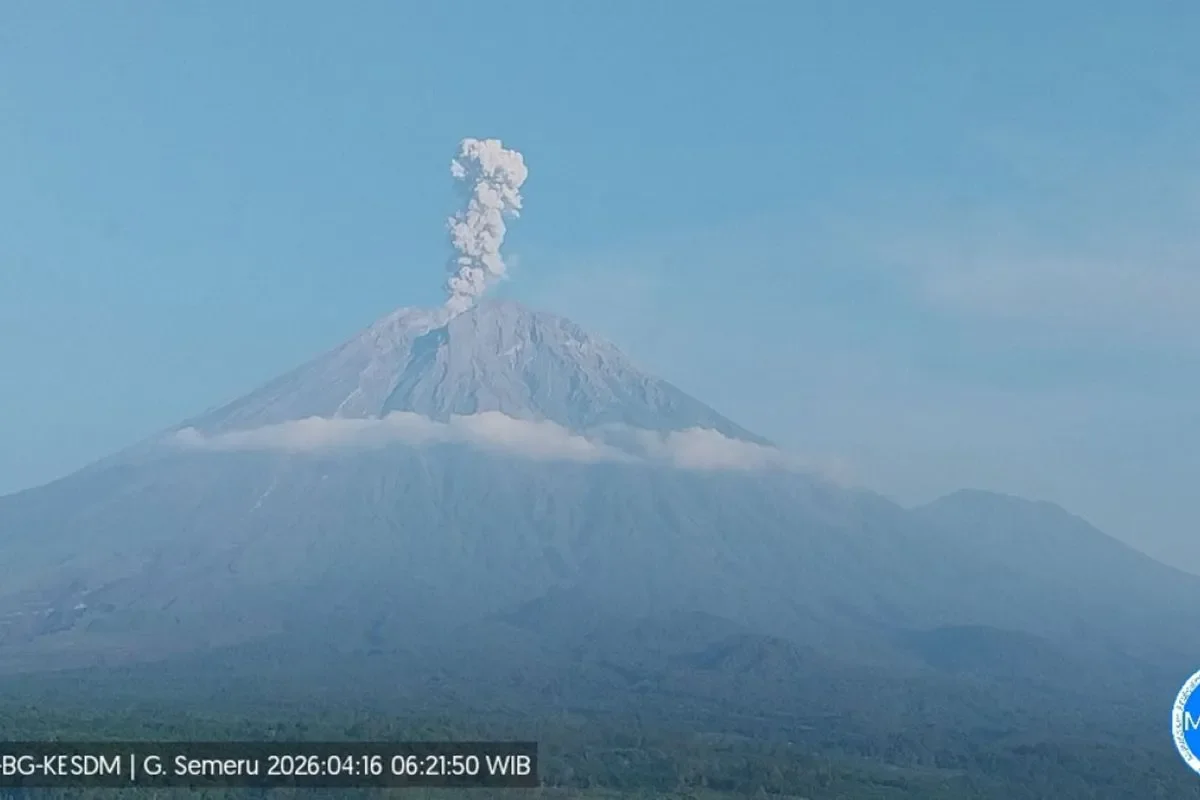
RRI.CO.ID, Lumajang - Mount Semeru, the highest peak on Java Island, experienced a series of five eruptions on Thursday morning, April 16, 2026. Monitoring officials reported that volcanic ash columns reached heights of up to 1,200 meters above the summit, drifting primarily toward the north, northwest, and northeast.
The volcanic activity began early in the morning with a succession of eruptions recorded by the Semeru Observation Post, starting at 05.11 local time when an initial blast sent an 800-meter ash column toward the north and northwest. This was followed at 06.21 local time by the strongest eruption of the morning, which produced a 1,200-meter plume reaching an altitude of 4,876 meters above sea level.
Shortly after, consecutive eruptions occurred at 06.57 and 07.08 local time, with ash columns reaching heights of 1,100 meters and 500 meters, respectively. The series concluded at 07.32 local time with a fifth eruption that sent a 700-meter column of volcanic material toward the north.
"The ash columns were observed to be white to gray with thick to medium intensity," said Liswanto, an officer at the Semeru Observation Post, as quoted by Antara.
Mount Semeru remains at Level III (Alert) status, prompting the Volcanology and Geological Hazard Mitigation Center (PVMBG) to issue strict safety mandates for residents and visitors in Lumajang and Malang. These mandates include a total ban on all activities within the southeastern sector along Besuk Kobokan, extending 13 kilometers from the summit.
Additionally, authorities have restricted access to river perimeters, prohibiting any activity within 500 meters of the riverbanks along Besuk Kobokan due to the risk of heat clouds and lahar flows that could extend up to 17 kilometers from the peak. To protect against the hazard of ejected volcanic rocks, a strict 5-kilometer summit radius from the crater has also been established as a primary danger zone.
Authorities have urged the public to remain vigilant for potential pyroclastic flows (hot clouds), lava avalanches, and lahars along all river valleys originating from the peak, specifically naming Besuk Kobokan, Besuk Bang, Besuk Kembar, and Besuk Sat.
The repeated eruptions of Semeru Volcano underscore the dynamic nature of Java's volcanic arc, requiring constant monitoring to protect surrounding agrarian communities. By enforcing a 13-kilometer exclusion zone in the Besuk Kobokan sector, PVMBG is prioritizing proactive disaster mitigation over reactive measures, effectively reducing the risk of casualties from pyroclastic flows.
Furthermore, the warning regarding lahar potential in secondary tributaries serves as a critical reminder of the secondary hazards associated with volcanic activity. Even during periods without rain, the accumulation of volcanic material combined with steep topography poses a significant threat to regional infrastructure and water safety, necessitating a holistic approach to public safety in the Lumajang and Malang regencies. ***
News Recomendation
Loading latest news.....