



Hotspots Rise by 209, Ground and Aerial Firefighting Operations Strengthened
- 21 Sep 2026 15:32 WIB
- Voice of Indonesia
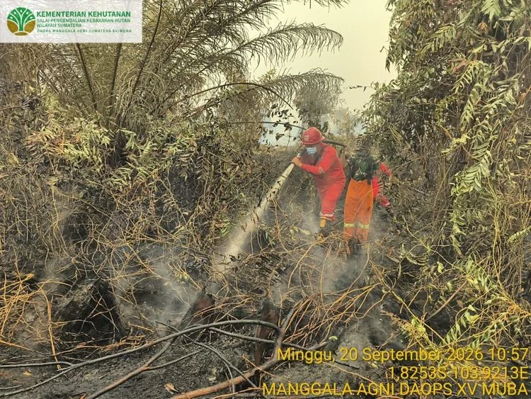
RRI.CO.ID, Jakarta – The government conducts efforts to control forest and land fires (karhutla) in several areas, particularly Central Kalimantan and South Sumatra, amid a rise in high-confidence hotspots. Based on data from the Ministry of Forestry’s SiPongi system, sourced from NASA’s Terra/Aqua, SNPP, and NOAA-20 satellites, a total of 1,532 high-confidence hotspots were detected nationwide as of Sunday, September 20, 2026, at 11:59 p.m. local time. The figure was up by 209 hotspots from 1,323 recorded on Saturday (Sept. 19).
Among the six priority provinces, Central Kalimantan recorded 968 hotspots, down from 1,035. South Sumatra saw a significant increase to 285 hotspots from 112. Meanwhile, West Kalimantan declined from 107 to 98 hotspots, and South Kalimantan from 55 to 39. Jambi increased from 14 to 26 hotspots, while Riau recorded one hotspot, up from none previously.
The Ministry of Forestry stressed that hotspots are indicators of surface temperature anomalies detected by satellites and cannot be directly equated with actual fires or the area burned. Each indication must be verified through field inspections and assessment of actual conditions at the site.
Cabinet Secretary Teddy Indra Wijaya, said the government has deployed 64 aircraft and helicopters, as well as 54,394 personnel from various agencies, since August to address forest and land fires in affected areas.
The operations include aerial and ground firefighting, efforts to prevent fires from spreading, mitigation of smoke impacts, and public protection. The aerial fleet consists of water-bombing helicopters, patrol helicopters, and aircraft supporting Weather Modification Operations.
On the ground, Manggala Agni under the Ministry of Forestry, together with the Indonesian Military (TNI), National Police (Polri), National Disaster Management Agency (BNPB), Meteorology, Climatology and Geophysical Agency (BMKG), Regional Disaster Management Agency (BPBD), local governments, communities, businesses, volunteers, and other stakeholders, are conducting patrols, field checks, direct firefighting, fire containment, mopping up, wetting, and cooling operations.
In Central Kalimantan, although the number of high-confidence hotspots has declined, smoke remains a challenge. Visibility at Tjilik Riwut Airport in Palangka Raya fell to around 600 meters on Sunday (Sept. 20), affecting 14 aircraft movements, comprising seven arrivals and seven departures.
Meanwhile, the BMKG warned that most parts of South Sumatra, particularly the central and eastern areas, could experience low rainfall and below-normal rainfall during the third 10-day period of September. The conditions could increase the risk of hotspots emerging in areas prone to forest and land fires.
The BMKG also recorded long to extremely long dry spells in several parts of South Sumatra, with some areas experiencing extreme drought for more than 60 days. The conditions have increased the vulnerability of vegetation and peatlands to fires. The government is also strengthening peatland wetting efforts through water management and water injection to maintain soil moisture during the dry season.
The Ministry of Forestry has urged residents in affected areas to follow air quality information and local government advisories. People are also advised to reduce outdoor activities when air quality deteriorates and wear masks when outdoor activities are unavoidable.
The public and businesses are reminded not to clear or prepare land by burning. Permit holders and land managers are urged to ensure adequate preparedness for fire prevention, early detection, and fire control in their respective areas.
News Recomendation
Memuat berita terbaru.....