



Govt Strengthens Forest and Land Fire Control in 6 Priority Provinces
- 30 Agt 2026 23:57 WIB
- Voice of Indonesia
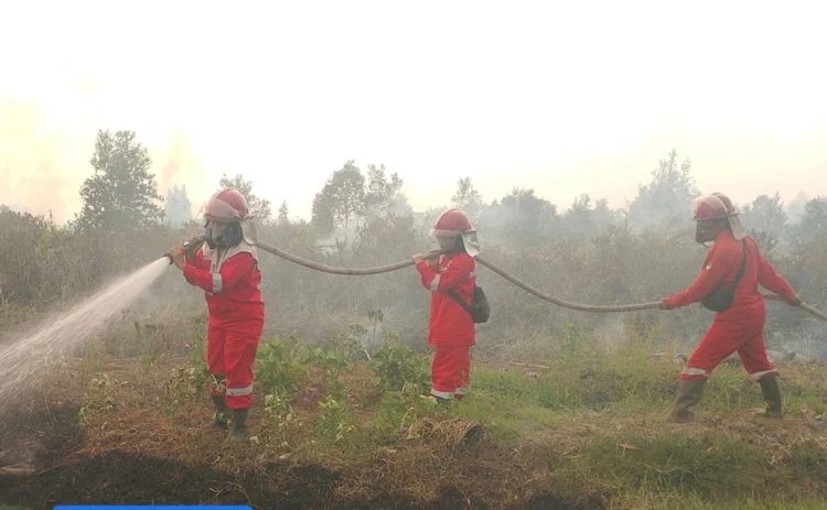
RRI.CO.ID, Jakarta – Indonesia’s Ministry of Forestry is strengthening efforts to control forest and land fires in six priority provinces amid fluctuations in hotspots and visibility conditions in several areas on August 28, 2026. The six provinces prioritized for forest and land fire control are Central Kalimantan, West Kalimantan, South Kalimantan, South Sumatra, Jambi, and Riau.
Based on monitoring by the Ministry of Forestry’s Forest and Land Fire Control Information System (SiPongi), using NASA Terra/Aqua, SNPP, and NOAA-20 satellites, a total of 18,065 hotspots were detected nationwide on August 28, 2026. The figure increased from 14,788 hotspots recorded on August 27, 2026. Despite the increase, the Ministry of Forestry recorded a decline in hotspots in several provinces, including South Sumatra, Riau, and Jambi.
South Sumatra recorded a decline from 1,281 hotspots to 1,036. Meanwhile, Riau, which recorded 491 hotspots on August 23 and 447 on August 24, had 265 hotspots on August 28. In Jambi, the number of hotspots fell to 86 on August 28, from 437 on August 23 and 361 on August 24.
On the other hand, an increase in hotspots was recorded in several areas of Kalimantan. Central Kalimantan saw hotspots rise from 5,041 to 7,703, West Kalimantan from 2,165 to 3,384, and South Kalimantan from 899 to 1,354.
The Ministry of Forestry remains on full alert for forest and land fires by strengthening patrols, ground checks, firefighting, firebreaks, mopping-up operations, and cooling efforts, supported by aerial operations. The priority areas were determined based on hotspot developments, the potential for fire spread, fuel conditions, peatland fire risks, and the impact on communities and the environment.
Operations in the six provinces are focused on areas where fires could potentially spread, approach residential areas, disrupt public facilities, or generate smoke pollution. In peatland areas, firefighting and cooling operations are carried out repeatedly to ensure that underground embers do not reignite.
In addition to ground operations, the government is preparing aerial support for water bombing and aerial patrols. Weather Modification Operations are also being pursued in areas and at times when meteorological conditions are suitable.
Based on observations by the Meteorology, Climatology, and Geophysical Agency (BMKG) on the morning of August 29, 2026, visibility remained limited in several provincial capitals. Visibility in Palangka Raya was recorded at three kilometers with smoky conditions, Pontianak at 0.8 kilometers and smoky, Banjarmasin at 0.5 kilometers and smoky, Jambi at 0.8 kilometers and smoky, and Pekanbaru at 2.5 kilometers and smoky.
Meanwhile, visibility in Palembang was recorded at six kilometers under partly cloudy conditions.
The Ministry of Forestry has urged the public not to clear or open land by burning. People in areas affected by smoke are also advised to monitor official information on air quality and visibility and adjust their activities if environmental conditions deteriorate.
The Ministry of Forestry emphasized that hotspots are indicators of surface temperature anomalies detected through satellite remote sensing and do not necessarily indicate an actual fire. Each indication still requires verification through ground checks and monitoring of field conditions.
Members of the public who spot smoke, fires, or indications of forest and land fires can report them to the Ministry of Forestry’s Forest and Land Fire Control Post at 021-5704618, via WhatsApp at +62 8131-00-35000, or by email at posko.karhutla@kehutanan.go.id.
News Recomendation
Memuat berita terbaru.....