



Hikers Urged to Follow Guidelines As Search for Dukono Eruption Victims Continues
- 09 Mei 2026 12:50 WIB
- Voice of Indonesia
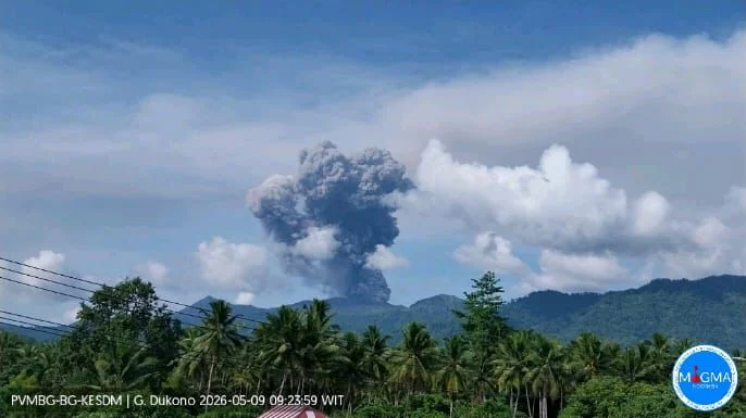
RRI.CO.ID, Tobelo – A joint search and rescue (SAR) team resumed search operations for three remaining missing hikers following the eruption of Mount Dukono in North Halmahera Regency, North Maluku, on Saturday, May 9, 2026. On the second day of the operation, the search focused on an area previously identified as the hikers’ likely location based on the team’s initial sweep on the first day.
"Executive Head of the North Halmahera Regional Disaster Management Agency (BPBD), Henjte M.L. Hetharia, who was also at the operation site, said that the joint SAR team continues to prioritize personnel safety given that Mount Dukono’s volcanic activity remains high," Indonesia's National Disaster Management Agency (BNPB) said in a statement received on Saturday.
Based on search results on Friday, May 8, 2026, two people from outside Indonesia were briefly detected. However, extreme terrain conditions and increased volcanic activity have prevented the evacuation process. All joint SAR personnel must move cautiously and follow the recommendations of the Dukono Volcano Observation Post, which is assisting with the operation.
Preliminary information indicates that the two are located approximately 20 to 30 meters from the rim of the main crater. According to the BNPB, this situation requires careful planning and a well-thought-out evacuation strategy, taking into account the potential for escalating volcanic activity and the safety of all personnel.
Meanwhile, one Indonesian climber remains unknown. The agency said the joint team intensifies its search efforts with the support of personnel, equipment, and supplies deployed at the operation site.
The Dukono Volcano Observation Post reported that Mount Dukono remains at Level II (Alert), which has been in effect since June 13, 2008. The Center for Volcanology and Geological Hazard Mitigation (PVMBG) has also designated a danger zone with a radius of four kilometers from the active crater since December 11, 2024.
PVMBG monitoring on Saturday up until 11:00 a.m. local time recorded several eruptions, with incandescent lava ejections observed from the post and an ash column reaching up to about 3,000 meters above the summit. It also noted that seismic activity at Mount Dukono is still dominated by eruption earthquakes with quite large amplitudes, indicating that the eruption is still ongoing with moderate intensity.
The North Halmahera Regency Government had previously officially banned all climbing activities on Mount Dukono on April 17, 2026, as well as prohibiting entry into the disaster-prone area within a 4-kilometer radius of the crater rim. A decree states that operators, managers, service providers, or any other parties are prohibited from granting climbing permits to anyone.
Through this decision, both the public and tourists are urged to obey the local government’s advisories and are prohibited from hiking from any access routes. Operators and service providers for Mount Dukono hikes are also requested to actively disseminate information regarding the closure of hiking trails and the potential dangers of an eruption to the public and tourists to ensure their safety.
The local government will monitor hiking activities in the Mount Dukono area. The BNPB said any violation of the regulations regarding the closure of hiking trails may be subject to sanctions in accordance with applicable laws and regulations.
News Recomendation
Memuat berita terbaru.....